Watson Lake is a tiny community, population ~1500, that serves local First Nations people and highway travelers with a few gas stations, a NAPA auto parts store and a couple of cafés. Its main claim to fame is the
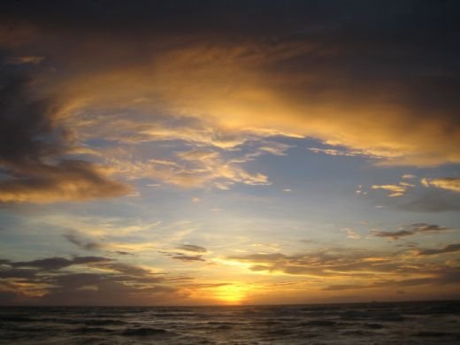
California sunset
One of our favorite camping spots on Rincon Parkway, old Route 1, between Ventura and Santa Barbara, CA
Route Map
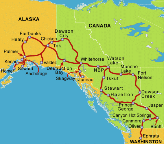
58-Day Alaska RV Caravan
Wednesday, July 25, 2007
The Signpost Forest at Watson Lake
The Alaska Highway to the Yukon
The next several days of our trip were spent in northern
We followed the edge of
The road criss-crosses the BC-YT border and winds more westerly than north for many miles. Historic Milepost 627 marks the official provincial border. Five miles later we reached our stop at
Saturday, July 21, 2007
Dawson Creek and Mile Zero of the Alaska Highway
The railroad ends at
Sunday, July 15, 2007
Out of the Rockies to Prince George
Friday, June 15, 2007
Columbia Icefields and the Athabasca Glacier
On Tuesday June 12, we left
Caravan Travel
We’ve now had several travel days to get a feel for the process of moving the group from place to place. In this caravan, we DO NOT travel nose-to-tail in a long string of vehicles. That would pose a traffic hazard and just wouldn’t work since there are few areas large enough for so many big rigs to pull off for rest stops and meal stops. Our wagon master just completed a long tour through
The group has already divided into the early birds, who often depart before the wagon master then pull over and linger somewhere so he can get ahead, and the trailers who leave well after the wagon master and get to camp right at the deadline. We often leave near the end of the group (Steve is NOT a morning person) but drive a little faster than some and pull into the destination in the middle of the pack.
Thursday, June 14, 2007
Lake Louise and Banff
On our second day in Canmore, we boarded a tour bus and motored down the
Our tour then took us to a high altitude lake,
We then motored to the town of
Leaving
After returning to Canmore, I had a few hours to sneak in a trip to the local quilt shop and then the grocery store while Steve did a load of laundry. Everyday chores continue even when on vacation when you take your house with you.
The Canadian Rockies
We spent June 9 – 13 in the Canadian Rockies. Leaving Oliver, in the south central part of
We passed through a series of small-to-medium sized towns, including
Of course, it began to rain as we arrived and set up camp. The snowy rocky slopes above us disappeared into fog and the temperature dropped. Still, the rain didn’t interfere with our trip to the mineral pools. The resort has two pools of spring water, one at 106 degrees and the other at 86 degrees. Steve and I spent nearly two hours alternating between the two as we soaked out the stiffness of the drive and talked with fellow travelers, including visitors from
Sunday morning began with another good rain shower but the mist began to lift just in time for our departure. We entered
Climbing further into the mountains took us into
We spent two nights in the resort town of
Wednesday, June 13, 2007
Across the Canadian Border
Thursday June 7, the caravan pulled out of Ephrata, bound for the Okanagan Valley of British Columbia. We went north on two lane roads through farms and orchards, along rivers and lakes, into the coulee area of eastern
We crossed the
We reached the Canadian border at Osoyoos, a smaller border station than the main one near
Our path into
On Friday afternoon our group toured three wineries, with talks by the vintners about their styles and methods of wine production. The area still gets hard winter freezes (most years) and one of the wineries specializes in the production of ice wines. To make ice wine, a vintner has to take a big risk and leave fruit on the vine until it freezes hard. The frozen berries are hand picked, often at 2 AM, and immediately pressed to separate a concentrated juice from the ice crystals. The wine is a sweet dessert wine with intense fruitiness. Another vintner specializes in wines made from fruit or fruit-grape blends. The third was a marvel of modern technology applied to winemaking. Then, we stopped for local fruit and produce. Strawberries and cherries were just coming into season and were perfectly ripe and sweet.
The Caravan Converges
On Monday June 4, we made our way east along the Columbia Gorge then north into
Tuesday, we traveled north through “Washington’s Palm Springs”, a region of high desert near Yakima, then into an area of orchards and alfalfa farms near Ephrata. Upon arriving at our rendezvous RV park, we met the wagon master and tail gunner staff of our caravan, as well as the other guests. The staff consists of two couples, the leaders, or wagon master, who handle the finances and logistics, and the tail gunners, who follow the guests, prepared to assist in case of breakdown or to rescue any one who gets lost.
The guests come from all over the
Our first afternoon and evening was spent in an orientation and get-acquainted meeting. The tail gunner Larry checked all the vehicles for soundness and assisted with minor maintenance issues. We had mail forwarded to General Delivery at the Ephrata post office so went into town to claim it and to find the RV supply dealer to pick up some forgotten items. Then, we made what we thought would be one last stop at Walmart to get Steve some sweatpants, since he thought he’d forgotten his. Well, there were no sweatpants at this time of year. It took stops at 4 more Walmarts on our way north before we found some in stock. Of course, several days after buying two pair, Steve found that he had indeed packed sweatpants but not sweatshirts!
Friday, June 8, 2007
The Columbia Gorge
We left the Monaco Service Center Friday morning, June 1 and drove about 150 miles past Portland to the Columbia River gorge. We found a spot at
We spent the weekend viewing waterfalls, including
Monday noontime, after returning from the tour, we moved east along the gorge, crossed the Columbia River into
Camp Monaco
A funny noise from the engine compartment turned out to be potentially serious. The dash air conditioner clutch was not releasing. It could have seized and, if it did, could have snapped the main drive belt. We would then have been “dead in the water” until we could be towed to a service facility to have a new belt installed. Luckily, the
Also, mechanic Mike at Top Flight Automotive in Junction City was able to locate and fix a gas leak in the Suzuki. Apparently, the gasket around the fuel sender at the top of the gas tank was not sealing. Now, we no longer smell gas dripping from the ‘Zuki (not a good thing when you’re towing it behind a motorhome full of gas and propane, with the potential of sparks from rocks or a dragging tow cable igniting the whole rig!).
Wednesday, June 6, 2007
Departure Day - at last!
Wednesday found us at Lake Shasta, in the wooded Forest Service campground at Lakehead. We noticed that the blooming wildflowers changed as we drove north - here the lupine was just finishing its bloom while at home it was long past. However, the lake was low - about the same level as we saw on our stop last August, despite the winter inflow. Just north of the lake, Mount Shasta still has a deep snow cover.
On Thursday May 24 we passed into Oregon and stopped at a membership RV park in Sutherlin, OR, north of Roseburg. Then we spent Memorial Day weekend with friends at Silver Falls State Park near Salem, OR. We had a light shower Sunday morning. It was nice to see water falling from the sky after Southern California's winter of drought. The woods are lush and green in Oregon and there are ferns and wildflowers everywhere. The lupine is in full spike and so thick at the edges of the woods that the ground is solid purple or blue. Silver Falls State Park is known for its waterfalls, including several where the trail goes behind the falls. We visited four waterfalls in two short hikes during the weekend. It's a unique experience to have water cascading over you while standing behind the fall. Each of our trips seems to develop a theme without our planning one. This time, the theme seems to be waterfalls - more about that later.
Sunday, May 20, 2007
D-day minus 1
First we stop in the Bay area to visit friends. We'll camp at Anthony Chabot Regional Park in Oakland (actually closer to Castro Valley) Monday and Tuesday. Then we head for Oregon - Wednesday night at the Antlers Forest Service Campground by Lake Shasta, Thursday night somewhere in southern Oregon then we meet friends near Salem, OR for a Memorial Day weekend campout at Silver Falls State Park.
The last week in May will be spent at the Monaco Coach Corp. Service Center in Harrisburg, OR. They will do some warranty work on the coach while we camp in "Camp Monaco", the campground on the premises.
June 1, we're headed for the Columbia Gorge and a fun time viewing the waterfalls that feed the Columbia River. (In ~1985, I took my mother, sister and niece on a trip through the Northwest. My niece and I especially remember climbing the cliff and walking BEHIND the waterfall at Multnomah Falls. I don't know if that's still possible but I look forward to visiting that site again.) We'll go as far east as Hood River then turn north into central Washington to arrive in Ephrata on June 5. Then, the adventure really begins!
Monday, April 16, 2007
Preparations
We had a spare tire for the coach mounted to a spare rim. The only place to carry this 100+ pound tire is in the cargo bay of the 'Zuki. So, we won't be able to carry firewood in that compartment. We'll have to buy local wood for campfires.
We have a service appointment next week for a thorough inspection and testing of all systems. We surely don't want the refrigerator to fail when we're days away from an RV service facility!
Then, it's time for the people and dogs to have their check-ups, too. The dogs need proof of recent vaccinations for all the usual diseases and an international health certificate in order to cross the borders. We humans need current passports to return from Canada back into the US. We also need to bone up on agricultural regulations in both directions. For example, no stone fruit can go into Canada and no potatoes or beef products (fresh or cooked) can go from Canada into the US.
In the final days before departure, we'll have to pack and load a 3-month supply of all the essentials - medicines, unusual toiletries, dog food (so they'll be sure to have their accustomed diet), books to read, movies to watch on the DVD player and so on. And, since it costs fuel money to drive every ounce around, we have to carefully consider and justify every item we pack.
After a year and a half of anticipation, we're nearly at D-day!