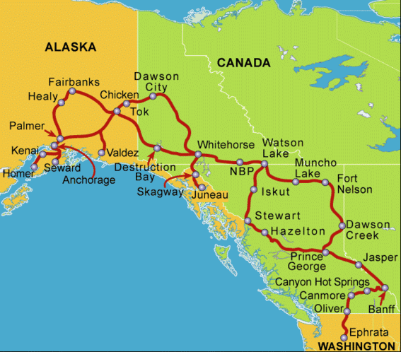
The railroad ends at Dawson Creek, BC. Travel further north must be by water (first in canoes and row boats, then by steamboat) or by over land. During the gold rushes and even after, there were pack trails but no road fit for vehicles until the start of World War II. Before the start of the war, the US began lending aircraft to the Russians and flew them north across Canada to Alaska then across the Bering Strait. A series of airports and fuel depots marked the route. After the Japanese invasion and occupation of several Aleutian islands, the US government decided to construct a road to Alaska. Construction actually began before receiving permission from the Canadian government! Dawson Creek was the starting point since men and equipment could be shipped in by train. So, it is officially Mile Zero of the highway. The route was surveyed, the land was cleared and a rough dirt one-lane track was completed with remarkable speed in 1942. Then a civilian organization began remaking the road into a more permanent and usable highway.
Now the Alaska Highway is a two-lane year round highway suitable for all forms of vehicle traffic. Passenger cars and trucks, big rigs and RV’s share the highway, especially in the summer (although many Up North residents claim to prefer to drive the road in the winter!). The road is fully paved, except in construction areas. We hope to be traveling early enough to avoid most of the road work, at least on our way north.
The West Access Road, Route 97 from Prince George to Dawson Creek, passes through boreal (northern; the antonym is australis or southern) forest of black and white spruce. There are many alpine lakes and rivers full of water in the early summer. The land rises gradually but steadily and as the elevation increases, the vegetation begins to thin. We actually cross the most western edge of the Canadian Rockies through Pine Pass. Dawson Creek sits on a high grassy plain with relatively few trees. Of course, many of the original trees in this area were harvested for fuel and building materials and the new growth is VERY slow due to the cold and short growing season. A 6-foot tall spruce may be nearly 100 years old!
We had an interesting stop along the way in the town of Chetwynd. This town sponsors an annual chain-saw caving competition. It had occurred the weekend before our arrival. The carvings are made out of a huge cedar log and many are 6-10 feet tall. The top 3 entries are kept in the town and are on display in front of the visitor’s center (for this year) and at street corners and public parks around town. Staff from the Visitor’s Center gave us a talk and a walking tour to see many of the statues. The detail and artistry is truly amazing, considering they have a limited time and are able to use only power tools.
Dawson Creek is surrounded by farmland – something I didn’t expect. Many of the farms grow grain like barley; others grow hay. There were some cattle ranches and game farms, one of which our group visited for a tour and dinner. The farm family has permits for both a zoo and for game meat production. They keep musk ox, mountain goats, elk and reindeer (domesticated caribou) on display and raise fallow deer, buffalo and wild boar for meat. Our dinner included dishes made from the game, served outdoors, picnic-style, next to their fish pond. Then we went on a hay ride out among the buffalo as our host feed them grain to lure them close to the truck.
The next morning we gathered at the Milepost Zero marker for a group photo. Then, we toured the Visitor’s Center, gathered literature on attractions in the area and went to the Saturday Farmer’s Market. Since it was so early in the season, the fresh vegetables were limited to rhubarb and leaf lettuce. However, vendors were selling fresh bread, pies and cookies, and homemade soap. I bought fresh bread, a strawberry-rhubarb pie and a bar of coffee soap that smells wonderful and has a mild abrasive action from some coffee grounds mixed into the bar. Then, we went to Safeway to stock up on milk and other groceries before heading off into the “wilds” of northern BC and the Yukon.
No comments:
Post a Comment