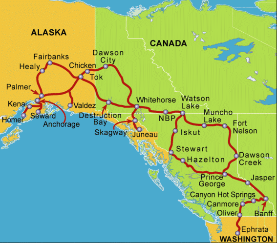
The next several days of our trip were spent in northern British Columbia. We had to drive about 500 miles before reaching the border of the Yukon Territory and our stop at Watson Lake, YT.
Leaving Dawson Creek, we detoured to visit the Kiskatinaw River Bridge. This is the last wooden bridge built by the Army Corps of Engineers during construction of the highway. The bridge is unique in that it curves sharply during its short span. It was bypassed years ago but still serves local traffic. Although advised to visit in our tow car, we decided to take the motor home across. We drove to the bridge, unhitched and drove the car across to check conditions, decided we could safely cross and negotiate the section of old road that returned to the main highway, then we went across. Elaine drove SLOWLY while Steve walked ahead taking pictures.
After returning to the main highway, we drove for many miles of gradual climb. A common experience was to gradually rise in elevation as the land tilts up toward the northern mountains, then drop sharply to a river crossing, climb a steep bank on the other side and then resume a slow but steady rise.
We passed through Fort St. John, the center of BC’s energy production, with oil derricks and natural gas wells. We spent one night in Fort Nelson, where there’s an interesting Heritage Museum and an actual trapper’s cabin where the family explains their life style. Continuing north, the land becomes rugged with high mountains, often with a lake at their base and a stream running through, paralleling the highway. Electric service ends just outside of Fort Nelson. The rest of the residents of northern BC have only the power provided by generators and heat is usually from wood-burning stoves. We stopped for a snack at Tetsa River Lodge, a typical roadhouse with a log lodge offering several rooms to highway travelers, a small café and a few RV camping spots. The hostess had baked fresh cinnamon buns and some pastries to offer our group. We climbed Stone Mountain, a rough, rocky peak but did not see any of the stone sheep or mountain goats that live in the area. Summit Pass at the top of Stone Mountain is the highest point on the highway at 4,250 feet. I was surprised at the relatively low elevation of the highway. We often visit the Sierra Nevada on both the east and west sides and are used to driving at 6-7,000 feet or higher!
We followed the edge of Muncho Lake, a beautiful big lake at the base of a mountain, where the road is just a few feet above lake level, especially in this unusually wet springtime. Then we climbed a bit to the Liard River for our next stopping place. We stayed at the Liard Hot Springs Lodge and RV Park. Liard in French means poplar and is named for the most abundant form of vegetation in the area. The provincial park directly across the highway from our campground protects and manages a unique set of hot springs. The hot water creates an almost tropical microclimate. Orchids bloom here and nowhere else in BC and the water remains ice-free even in the winter. One walks along a wooden boardwalk across ponds filled by the cooling spring water, through the equivalent of a rain forest created by the steam and mist, to the outdoor lower (cooler) pool. After an additional 10-minute uphill climb you reach the upper hot pool (bears are commonly seen along the path to the upper springs!). We found the hot pool too hot and stayed at the lower pool which is more developed with a restroom and changing house. Rock lines the pool and there’s natural gravel on the bottom. The water is about 3 feet deep, and a stone wall with a small waterfall separates the hotter upper end from a cooler shallower “kid’s pool”. The water has high sulfur content, to the dismay of several of our traveling companions who made the mistake of wearing silver jewelry into the water. The silver quickly turned black with tarnish due to the heat and dissolved sulfur. We had a 24-hour pass to the hot springs so we returned for another soak the following morning before departing.
Leaving Liard Hot Springs, we headed for the BC-YT border. The road is generally in good condition, although there are some rough patches and especially many bouncy transitions onto and off of bridges. A herd of woodland bison leaves in the forest and we saw two large bulls grazing along the road side. Fifty miles north of Liard, we stopped for a snack at the Fireside Café. This area had a fire in 1982 that destroyed more than 400,000 acres. The forest is recovering slowly with willow and poplar (aspen) saplings and a few very small spruce seedlings. The café is run by an older couple; she cooks breakfast and lunch and he tries not to wait tables and clear up. The specialty of the house is cream pies – 4 or 5 different varieties, all scrumptious. We had burgers and took a huge slice of Black Russian pie back to the RV. I enjoyed that pie for the next two days.
The road criss-crosses the BC-YT border and winds more westerly than north for many miles. Historic Milepost 627 marks the official provincial border. Five miles later we reached our stop at Watson Lake, a truck stop/gas station/campground on the outskirts of town. We have reached the Yukon!
No comments:
Post a Comment