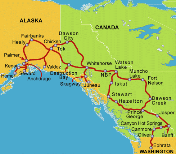
We spent June 9 – 13 in the Canadian Rockies. Leaving Oliver, in the south central part of British Columbia, we traveled north and east through the Okanagan Valley and into the western foothills of the mountain range. This area has many rivers emptying into beautiful clear blue lakes. The biggest is Okanagan Lake, home of the fabled lake monster Ogopogo. The prettiest, Lake Kalamalka, has many colors of blue and green striping its surface and is so clear and still that the reflections of the surrounding hills are as clear as the hills themselves.
We passed through a series of small-to-medium sized towns, including Kelowna, the third most populous “city” in BC. Each town quickly yields to open land, increasingly forested and gradually getting higher and more rugged. Then, you realize that you really are in the middle of a mountain range with steep angles of descent for the creeks and rivers. There are a series of waterfalls, many of them seasonal but running at high volume this unusually wet spring. The terrain remains thickly forested; often, you can’t see more than 5 feet into the woods from the road. We passed Mount Revelstoke, and the community of Revelstoke, and continued to climb to Albert Canyon and the Canyon Hot Springs Resort.
Of course, it began to rain as we arrived and set up camp. The snowy rocky slopes above us disappeared into fog and the temperature dropped. Still, the rain didn’t interfere with our trip to the mineral pools. The resort has two pools of spring water, one at 106 degrees and the other at 86 degrees. Steve and I spent nearly two hours alternating between the two as we soaked out the stiffness of the drive and talked with fellow travelers, including visitors from England, Denmark and Germany as well as our American companions.
Sunday morning began with another good rain shower but the mist began to lift just in time for our departure. We entered Glacier National Park (the Canadian one, not the Montana park) and climbed above the tree line. The bare cliffs still had snow, especially in shady or north-facing areas. We could see large ice fields and small glaciers hanging from high elevations. Rogers Pass Summit has an interesting visitor’s center with displays about the first European explorers of the region. A small valley in the mountain range houses the town of Golden, whose riverfront farms and fields were flooded as the river was over its banks.
Climbing further into the mountains took us into Yoho National Park and cost us an hour as we entered the Mountain Time Zone. Then we crossed the Continental Divide into the province of Alberta. Suddenly, rivers flowed to the east, eventually emptying into the Atlantic Ocean rather than west to the Pacific. An interesting feature in this area is the spiral railroad tunnel. Freight trains in western Canada can be very long, sometimes 1½ miles long. The “big mountain” was a formidable barrier to these trains, so engineers reduced the grade, and eased passage over this mountain by building a spiral tunnel through the heart of the mountain. Some of our group were fortunate enough to see a freight pass through the tunnel while they watched. The engine entered the tunnel and emerged some time later high up the slope, while freight cars were still outside the mountain at the tail end.
We spent two nights in the resort town of Canmore, Alberta. The eastern side of the Rockies is much more rugged, rocky and drier than the western slopes. From our campground, we looked straight up at jagged gray granite peaks, including the Three Sisters which are the logo of the town. The first evening we attended a dinner show called “Oh Canada, Eh!” in Canmore. The servers are also performers in a revue of Canadian history and culture with a humorous tone. It was a fun evening and a nice break from camp food.


1 comment:
It sounds like you are having fun. But there are no sample pictures of what I am sure is spectacular scenery!
Post a Comment