March, 2007 Share our excitement as we prepare for the vacation of a lifetime!

The Carters, human and canine, are preparing for a motorhome trip through British Columbia, the Canadian Rockies, the Yukon and Alaska. We will be traveling in our 31-foot motorhome, a Holiday Rambler Admiral 30PDD, and towing our 4-wheel-drive Suzuki Samurai for off-road exploring. We rented a motorhome in the summer of 2002 for a tour of the National Parks of Arizona, New Mexico, Colorado and Utah. After 17 days and 3000 miles, we returned the rental coach and went RV shopping almost immediately. We bought a 25-foot Georgie Boy Landau and traveled frequently for the next 3½ years. Then, we decided we wanted to go to Alaska and began preparing for the trip. First, we traded up to a roomier coach, our current HR Admiral. We ordered the coach from the factory, waiting over 3 months for it to be built with our chosen options. We included a bigger AC, dual-pane windows and extra batteries, all with an eye towards this trip. We have installed solar panels and an inverter so we can camp without services anywhere along the way. Now, with 2 months remaining before departure, we are packing and organizing our supplies for a 3-month adventure through all types of terrain and climate.

California sunset

California sunset
One of our favorite camping spots on Rincon Parkway, old Route 1, between Ventura and Santa Barbara, CA

Route Map

Route Map
58-Day Alaska RV Caravan

Wednesday, July 25, 2007

The Signpost Forest at Watson Lake

Watson Lake is a tiny community, population ~1500, that serves local First Nations people and highway travelers with a few gas stations, a NAPA auto parts store and a couple of cafés. Its main claim to fame is the Signpost Forest, an attraction for tourists from all over the world. The whole thing began during the construction of the military road in 1942. There was an airport at Watson Lake as a refueling stop for the ferrying of supplies to Alaska and planes to Russia. Thus, the town became a main staging point for construction supplies as well. A homesick soldier posted a sign post pointing to his hometown and others followed suit. Then, passers-by added more signs. The town now hosts the Alaska Highway Interpretive Centre, operated by Tourism Yukon, and installs and maintains the posts for visitors who add to the collection. At the time of our visit, there were about 65,000 signs and many were added on the day of our stop. The caravan posted a sign and I posted a marker for L.A. City College. We found signs from familiar communities, including many from Southern California and several from our native states of Connecticut and Rhode Island. Some foreign visitors had also posted signs and I think that if you searched hard enough you could account for almost every country of the world. When I returned later in the day for some more pictures, there were already some 20 additional signs on the posts near ours and people were still arriving even late in the evening.

Watson Lake also has the Northern Lights Centre, a planetarium-style auditorium that entertains and educates visitors about space and the aurora borealis. We enjoyed the show and the exhibits featuring Canadians in space. Several NASA astronauts have been Canadian and the Centre displayed mission memorabilia.

Gas in Canada is sold by the liter (litre in Canadian spelling) and has been getting steadily more expensive as we travel north. Our Watson Lake fill-up cost C$1.26 per liter. With 3.6 L per gallon for a 40-gallon fill, you can do the math! Plus, the credit card company charges a 3% conversion fee. Since the Canadian dollar is currently about 4% below the value of the greenback, we end up at about par. We’ve vowed not to worry about fuel prices, although we still hunt for the best price at each fuel stop. Still, fuel for the trip will cost more than we expected and the fuel expense has limited our spending for souvenirs and gifts. We’ve been warned that prices will continue to rise as we move into more remote areas!

The Alaska Highway to the Yukon

The next several days of our trip were spent in northern British Columbia. We had to drive about 500 miles before reaching the border of the Yukon Territory and our stop at Watson Lake, YT.

Leaving Dawson Creek, we detoured to visit the Kiskatinaw River Bridge. This is the last wooden bridge built by the Army Corps of Engineers during construction of the highway. The bridge is unique in that it curves sharply during its short span. It was bypassed years ago but still serves local traffic. Although advised to visit in our tow car, we decided to take the motor home across. We drove to the bridge, unhitched and drove the car across to check conditions, decided we could safely cross and negotiate the section of old road that returned to the main highway, then we went across. Elaine drove SLOWLY while Steve walked ahead taking pictures.

After returning to the main highway, we drove for many miles of gradual climb. A common experience was to gradually rise in elevation as the land tilts up toward the northern mountains, then drop sharply to a river crossing, climb a steep bank on the other side and then resume a slow but steady rise.

We passed through Fort St. John, the center of BC’s energy production, with oil derricks and natural gas wells. We spent one night in Fort Nelson, where there’s an interesting Heritage Museum and an actual trapper’s cabin where the family explains their life style. Continuing north, the land becomes rugged with high mountains, often with a lake at their base and a stream running through, paralleling the highway. Electric service ends just outside of Fort Nelson. The rest of the residents of northern BC have only the power provided by generators and heat is usually from wood-burning stoves. We stopped for a snack at Tetsa River Lodge, a typical roadhouse with a log lodge offering several rooms to highway travelers, a small café and a few RV camping spots. The hostess had baked fresh cinnamon buns and some pastries to offer our group. We climbed Stone Mountain, a rough, rocky peak but did not see any of the stone sheep or mountain goats that live in the area. Summit Pass at the top of Stone Mountain is the highest point on the highway at 4,250 feet. I was surprised at the relatively low elevation of the highway. We often visit the Sierra Nevada on both the east and west sides and are used to driving at 6-7,000 feet or higher!

We followed the edge of Muncho Lake, a beautiful big lake at the base of a mountain, where the road is just a few feet above lake level, especially in this unusually wet springtime. Then we climbed a bit to the Liard River for our next stopping place. We stayed at the Liard Hot Springs Lodge and RV Park. Liard in French means poplar and is named for the most abundant form of vegetation in the area. The provincial park directly across the highway from our campground protects and manages a unique set of hot springs. The hot water creates an almost tropical microclimate. Orchids bloom here and nowhere else in BC and the water remains ice-free even in the winter. One walks along a wooden boardwalk across ponds filled by the cooling spring water, through the equivalent of a rain forest created by the steam and mist, to the outdoor lower (cooler) pool. After an additional 10-minute uphill climb you reach the upper hot pool (bears are commonly seen along the path to the upper springs!). We found the hot pool too hot and stayed at the lower pool which is more developed with a restroom and changing house. Rock lines the pool and there’s natural gravel on the bottom. The water is about 3 feet deep, and a stone wall with a small waterfall separates the hotter upper end from a cooler shallower “kid’s pool”. The water has high sulfur content, to the dismay of several of our traveling companions who made the mistake of wearing silver jewelry into the water. The silver quickly turned black with tarnish due to the heat and dissolved sulfur. We had a 24-hour pass to the hot springs so we returned for another soak the following morning before departing.

Leaving Liard Hot Springs, we headed for the BC-YT border. The road is generally in good condition, although there are some rough patches and especially many bouncy transitions onto and off of bridges. A herd of woodland bison leaves in the forest and we saw two large bulls grazing along the road side. Fifty miles north of Liard, we stopped for a snack at the Fireside Café. This area had a fire in 1982 that destroyed more than 400,000 acres. The forest is recovering slowly with willow and poplar (aspen) saplings and a few very small spruce seedlings. The café is run by an older couple; she cooks breakfast and lunch and he tries not to wait tables and clear up. The specialty of the house is cream pies – 4 or 5 different varieties, all scrumptious. We had burgers and took a huge slice of Black Russian pie back to the RV. I enjoyed that pie for the next two days.

The road criss-crosses the BC-YT border and winds more westerly than north for many miles. Historic Milepost 627 marks the official provincial border. Five miles later we reached our stop at Watson Lake, a truck stop/gas station/campground on the outskirts of town. We have reached the Yukon!

Saturday, July 21, 2007

Dawson Creek and Mile Zero of the Alaska Highway

The railroad ends at Dawson Creek, BC. Travel further north must be by water (first in canoes and row boats, then by steamboat) or by over land. During the gold rushes and even after, there were pack trails but no road fit for vehicles until the start of World War II. Before the start of the war, the US began lending aircraft to the Russians and flew them north across Canada to Alaska then across the Bering Strait. A series of airports and fuel depots marked the route. After the Japanese invasion and occupation of several Aleutian islands, the US government decided to construct a road to Alaska. Construction actually began before receiving permission from the Canadian government! Dawson Creek was the starting point since men and equipment could be shipped in by train. So, it is officially Mile Zero of the highway. The route was surveyed, the land was cleared and a rough dirt one-lane track was completed with remarkable speed in 1942. Then a civilian organization began remaking the road into a more permanent and usable highway.

Now the Alaska Highway is a two-lane year round highway suitable for all forms of vehicle traffic. Passenger cars and trucks, big rigs and RV’s share the highway, especially in the summer (although many Up North residents claim to prefer to drive the road in the winter!). The road is fully paved, except in construction areas. We hope to be traveling early enough to avoid most of the road work, at least on our way north.

The West Access Road, Route 97 from Prince George to Dawson Creek, passes through boreal (northern; the antonym is australis or southern) forest of black and white spruce. There are many alpine lakes and rivers full of water in the early summer. The land rises gradually but steadily and as the elevation increases, the vegetation begins to thin. We actually cross the most western edge of the Canadian Rockies through Pine Pass. Dawson Creek sits on a high grassy plain with relatively few trees. Of course, many of the original trees in this area were harvested for fuel and building materials and the new growth is VERY slow due to the cold and short growing season. A 6-foot tall spruce may be nearly 100 years old!

We had an interesting stop along the way in the town of Chetwynd. This town sponsors an annual chain-saw caving competition. It had occurred the weekend before our arrival. The carvings are made out of a huge cedar log and many are 6-10 feet tall. The top 3 entries are kept in the town and are on display in front of the visitor’s center (for this year) and at street corners and public parks around town. Staff from the Visitor’s Center gave us a talk and a walking tour to see many of the statues. The detail and artistry is truly amazing, considering they have a limited time and are able to use only power tools.

Dawson Creek is surrounded by farmland – something I didn’t expect. Many of the farms grow grain like barley; others grow hay. There were some cattle ranches and game farms, one of which our group visited for a tour and dinner. The farm family has permits for both a zoo and for game meat production. They keep musk ox, mountain goats, elk and reindeer (domesticated caribou) on display and raise fallow deer, buffalo and wild boar for meat. Our dinner included dishes made from the game, served outdoors, picnic-style, next to their fish pond. Then we went on a hay ride out among the buffalo as our host feed them grain to lure them close to the truck.

The next morning we gathered at the Milepost Zero marker for a group photo. Then, we toured the Visitor’s Center, gathered literature on attractions in the area and went to the Saturday Farmer’s Market. Since it was so early in the season, the fresh vegetables were limited to rhubarb and leaf lettuce. However, vendors were selling fresh bread, pies and cookies, and homemade soap. I bought fresh bread, a strawberry-rhubarb pie and a bar of coffee soap that smells wonderful and has a mild abrasive action from some coffee grounds mixed into the bar. Then, we went to Safeway to stock up on milk and other groceries before heading off into the “wilds” of northern BC and the Yukon.

Sunday, July 15, 2007

Out of the Rockies to Prince George

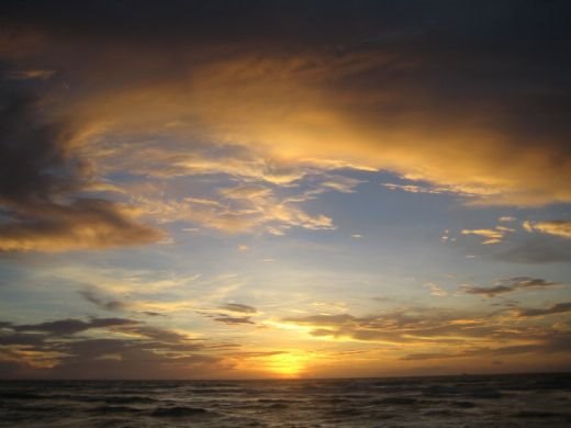
We pulled out of Columbia Icefields Visitor’s Center early on a cold gray morning. The overnight temperature had flirted with 0C but we didn’t worry about freezing the water pipes since we had heat inside the coach and a large mass of water in the tanks. Icefields Parkway passes several nice waterfalls as it goes north. We stopped at both Sunwapta Falls and Athabasca Falls for pictures and a leg stretch.

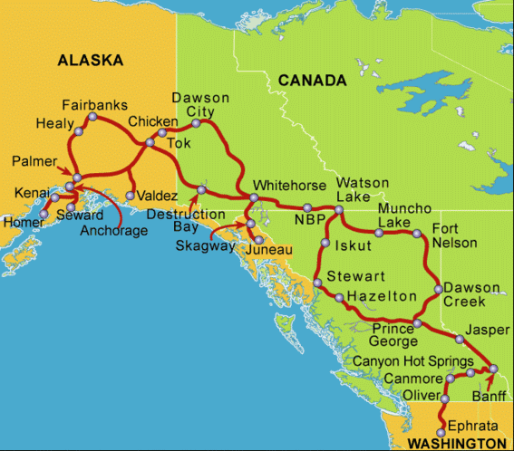
We traveled northwest toward the town of Jasper but turned off onto the access road to Jasper Tramway to the top of Whistler Mountain at the 7,496-foot level. The access road was the steepest we’ve seen. We had to climb it in first gear; second just wouldn’t do! At the tram base station, we saw that the mountain was clouded over at the top but decided to go up anyway. The scenery was spectacular during the ascent. We saw many lakes, some clear and others full of glacial silt, the railroad line and a mile-long train laboring west, and the path of the westbound Highway 16, the Yellowhead Highway, that we would be taking to our next destination.

The summit of Whistler Mountain was bathed in a cloud and was getting snow flurries as we exited the tram car. It was COLD up there. We bundled up, went for a short walk around near the summit amid piles of old snow and a light dusting of new powder, then returned to the base. Most of the visitors didn’t stay out long. It was colder and wetter than we had been during our night at Columbia Icefields. The clouds were lifting as we descended but didn’t promise to clear anytime soon. So, we got back in the coach, drove down to the highway and turned west. Leaving the town of Jasper, we passed an RCMP speed trap with a couple of cars and one big rig pulled over in both directions. We were glad that we had been observing the speed limit! Although we’ve seen little police presence on the highways during our travels, this reminded us to be considerate visitors.

The Yellowhead Highway is considered one of Canada’s most scenic routes and lives up to its reputation. It is named for a blonde French trapper of the early 1800’s, nicknamed Tete Jaune, who had a cabin and cache nearby. The route passes out of Alberta at the western boundary of Jasper National Park and enters British Columbia into Mount Robson Provincial Park. Mt. Robson is the tallest peak in the Canadian Rockies at 12,972 feet. The area is a center for rafting and trout fishing. We stopped at the Visitor’s Infocenter at the park to pick up literature on our next destination and to walk the dogs. Missy charmed an entire rafting group who had just been picked up; she got lots of attention and petting from the wet and weary riders and crew.

At the western edge of the park, we detoured several miles south to the northern edge of Valemount for our next stop. Valemount is a town of ~1200 on the plain at the very edge of the mountains, a pretty spot but also an important intersection of several roads across Canada. So, there’s fuel and traveler’s services; these services represent the major economy of the town.

The following morning, we returned to the Yellowhead Highway, passing through the community of Tete Jaune Cache and on to Prince George. The road ran along the Fraser River, through a dense conifer forest, across many creeks and through moose habitat. Sure enough, we saw several moose and even had to stop for one who was planted in the middle of the road at the crest of a small rise. We turned off into a rest area near the Goat River Bridge and found ourselves in a bit of a pickle. The “rest area” single-lane road had a steep downhill grade to a small turnaround. However, the turnaround wasn’t big enough for us with the Suzuki in tow. After starting to turn, and realizing we couldn’t make it around, we had to unhitch the car. This is difficult when on a grade and even more so when the car is turned at a sharp angle to the coach. As a further complication, another motorhome had followed us into the rest area and was now patiently waiting for us to clear the road so they too could turn around and come back up to the picnic tables and rest rooms. After some struggle, we got unhitched, were able to back and fill to get the motorhome turned around, then pulled up and out of the way by the picnic area. We chatted with the other coach’s occupants, a couple and their dog from Alberta, then watched them as they completed the same turn. They weren’t towing a car so got around fine on the first try. It was a gorgeous little spot right next to the river and we lingered for a while to better appreciate the sort of pocket pull-out that we would be more careful to avoid in the future.

After a trip of 184 miles, we arrived in Prince George, BC. This is a surprisingly large industrial city with all the amenities including a Walmart and Costco. We were glad to have services available once more. Missy had wrenched her leg several days earlier and was limping. Her hock was tender and she objected vocally to anyone touching it. We didn’t see much improvement and wanted to have a vet look at her injury. The proprietor of Southpark RV Park graciously called his personal veterinarian, who cares for his prize Chesapeake Bay Retrievers, and made us a drop-in appointment. The animal hospital was short-handed that day but the staff still served us promptly and were very kind and understanding. Missy, luckily, didn’t have a serious injury – just a sprain or stretched ligament rather than the torn ligament that I feared. We left with an anti-inflammatory/painkiller to ease her discomfort. We were in and out with enough time to stop at Costco for a shrimp cocktail tray to take to the caravan’s social hour and travel meeting at 4PM.

Several additional coaches joined us at Prince George for the trip to Alaska. We now have 18 client coaches with 37 guests plus wagon master and tailgunner couples.

Friday, June 15, 2007

Columbia Icefields and the Athabasca Glacier

On Tuesday June 12, we left Canmore, AB early and returned to the Trans-Canada Highway heading westbound this time. The early morning hours brought a squall through the area. We had some pre-dawn rain but there was fresh snow on the slopes several hundred feet higher – beautiful to see as the clouds lifted and the air cleared! We went through the tollbooth at the entrance to Banff National Park and bought day use passes for the very reasonable cost of $9.95 Canadian for adults and $8.65 for seniors. Then we drove back past the exits for the town of Banff and for Lake Louise (and could have stopped again if we wished and had time in the travel schedule) and turned off onto Highway 93 North, Icefields Parkway. The road climbed steeply to a summit at nearly 7,000 feet, above the treeline and in a rugged rocky barren wilderness. We stopped to view yet another waterfall (not the last by any means) called Bridal Veil Falls and entered Jasper National Park.

The Columbia Icefields Visitor’s Center has interesting displays about the geography and climate that created the icefield and its hundreds of associated glaciers. And, more importantly, they offer excursions onto the Athabasca Glacier in a snowcat. Our group was shuttled to the edge of the glacier, boarded a vehicle with huge balloon tires and traveled out onto the glacier. We left the vehicle and were able to walk on the ice, drink some of the glacier melt water and get a close-up view of other nearby glaciers, some part of the Columbia system, some independent. An independent cirque glacier was directly overhead within the peak of a nearby mount while an impressive hanging valley glacier loomed over us as we made our way out and back to the excursion dock. One of the nearby peaks serves as a triple continental divide. Water runs off it into 3 different oceans, the Pacific, the Atlantic and…(Can you guess the third? Yes, the Arctic.) Not surprisingly, it was VERY cold on the glacier. I wore a shirt, sweatshirt, parka, jeans, sweatpants over the jeans, gloves, a knit cap and my parka hood for our 30 minutes out on the ice.

While waiting for the shuttle to the glacier, we were entertained by several mountain goats on an almost vertical cliff above the Visitor’s Center. They were hard to spot with the naked eye but easily followed with binoculars.

We parked our motor home in the lower parking lot of the Visitor’s Center, where we could stay the night. The temperature dropped and it began to snow lightly. The wind picked up and everyone huddled inside our homes on wheels. Steve and I invited Laurie and Dan, who are traveling in a 17 foot Casita (a fiberglass torpedo-shaped trailer), to join us for a movie on our DVD player. They had very limited propane and battery capacity so were worried about staying warm. We set up our catalytic propane heater, kept us all cozy for several hours and enjoyed a DVD. Then we all turned in and bundled up snug in our beds. The overnight low was close to freezing and the cold wind found its way in every crack and poor seal in our units. The light lingered long in the evening, past 11 PM, then reappeared before 4 AM. This is a foretaste of what we should experience in the Yukon and Alaska. The morning was again very windy with light snow flurries so we hitched up quickly and drove off toward the town of Jasper.

Caravan Travel

We’ve now had several travel days to get a feel for the process of moving the group from place to place. In this caravan, we DO NOT travel nose-to-tail in a long string of vehicles. That would pose a traffic hazard and just wouldn’t work since there are few areas large enough for so many big rigs to pull off for rest stops and meal stops. Our wagon master just completed a long tour through Mexico and Central America where they did travel in a convoy but the group was smaller and the local conditions (language barrier and security) made it desirable to keep everyone together. Instead, we travel “scattered”.

A typical day begins rather early. Don’t worry; we still get plenty of rest since campers tend to turn in early as well. At the previous evening’s travel meeting, the wagon master discusses the route, reviews any hazards and points of interest then announces his departure time and our expected arrival time at the next destination. The leader’s departure is usually 7:30 – 8 AM. Guests should depart in small groups spaced out over the next hour. The tail gunner’s rig leaves a little while after the last guest. We check in with the tail gunner by CB each morning to confirm that we are up and preparing to leave, then again as we depart. We can talk by CB with anyone else in range, for example to pass word back about wildlife or road conditions. We are free to stop wherever and as often as we wish while completing the day’s journey by the arrival deadline. The tail gunner keeps his coach at the end of the string while the wagon master must be the first to arrive at the next stop to complete the arrangements.

The group has already divided into the early birds, who often depart before the wagon master then pull over and linger somewhere so he can get ahead, and the trailers who leave well after the wagon master and get to camp right at the deadline. We often leave near the end of the group (Steve is NOT a morning person) but drive a little faster than some and pull into the destination in the middle of the pack.

The next hour or so is spent parking, hooking up electric and water service (and sometimes the TV cable, yes even in rural areas), and sewage dump hose. Then, when we don’t have a planned evening activity, we gather in small groups, break out the lawn chairs and some refreshments and talk – about previous trips, our RV’s and their features or faults, family or jobs, the day’s sights … The social chitchat is quickly becoming more intimate and meaningful as we get to know each other better. Friendships develop quickly in these circumstances. We chose to travel to Alaska as part of a caravan, rather than by ourselves, for the company and comfort of having companions on the trip. We feel we are getting much more out of this trip by sharing it with our fellow travelers than we would have by going alone.

Thursday, June 14, 2007

Lake Louise and Banff

On our second day in Canmore, we boarded a tour bus and motored down the Trans-Canada Highway, Route 1, for a visit to Lake Louise and Banff. Once again, the weather was gray and showery, at least in the morning. It was raining steadily when we reached Lake Louise and the damp chill limited our time outside. Still, the lake was beautiful and we could imagine how spectacular it would be on a clear day. The lake is glacier-fed, deep, cold and normally a brilliant blue color. The Chateau (hotel) at lakeside is magnificent and very posh. Tour groups, especially from Asia, were loading onto their buses as we arrived. I walked about 20% of the lake shore, got thoroughly wet and enjoyed coming in to the inviting hotel lobby to warm up.

Our tour then took us to a high altitude lake, Moraine Lake, which formed several thousand years ago when a rock slide dammed a mountain stream. There is a charming rustic lodge on the lake shore – the complete antithesis to Chateau Lake Louise.

We then motored to the town of Banff. Again, there is a posh resort hotel but also many hostels, motels and bed and breakfast establishments. Our bus driver drove across the Bow River Bridge, with water just below the roadway and commented that the river was the highest in anyone’s memory and 60% of the snowpack had yet to melt! We visited Bow River Falls and noticed that the city officials had closed off the path along the river’s edge due to the high water. We then had several hours for lunch and a chance to explore the museums and/or shops of the town.

Leaving Banff, our bus traveled a secondary road along the Bow River with some spectacular scenery. Near a small lake, we passed a group of bighorn sheep grazing near a roadside rest area. They seemed remarkably unconcerned about the vehicle traffic. There were several lambs with their mothers, and several rams with a full curl of horn. They were shedding their winter coats so looked rather moth-eaten.

After returning to Canmore, I had a few hours to sneak in a trip to the local quilt shop and then the grocery store while Steve did a load of laundry. Everyday chores continue even when on vacation when you take your house with you.